 AMI-16149AMI-16149
 0
0
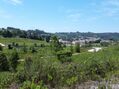
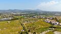
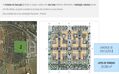
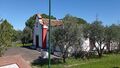
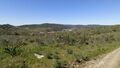
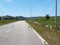 REF AV-PBI-1253151.950m²Important allotment with Alcobaça whose urbanization works were approved by the CMA, for housing (single-family and multi-family), commerce and services, with a total Gross Construction Area (ABC) of 151,950sqm. Energy Class: Exempt The current city of Alcobaça has grown in the valleys of the Alcoa River and the Baça River. The area of the current municipality of Alcobaça was inhabited by the Romans, but the denomination was left to it by the Arabs, whose occupation denotes an era of progress judging by the numerous toponyms of the adjacent lands that remind them, such as Alcobaça, Alfeizerão, Aljubarrota, Alpedriz and other toponyms. When Alcobaça was reconquered, the locality had access to the nearby sea that formed the great Pederneira Lagoon that reached Cós and allowed them to sail the vessels that transported to the rest of the country the delicious fruits produced in the region thanks to the technique introduced by the monks of Cisterer. Afonso Henriques sweetened the Lands of Alcobaça to the Cistercian monks on April 8,1153, with the obligation to burp them; the donations made over the various reigns came to constitute a vast territory - The Coutos of Alcobaça - ranging from about São Pedro de Moel to São Martinho do Porto and from Aljubarrota to Alvorninha, and the territory reached its maximum in the reign of D. Fernando I. The monks of Cistermen came to be lords of 14 villages of which 4 were sea ports: Alfeizerão, São Martinho do Porto, Pederneira and Paredes da Vitória. The monks of Alcobaça, in addition to their religious and cultural activity- have had public classes since 1269 and in them, in addition to Humanities, Logic and Theology, taught agricultural techniques - developed a remarkable and lasting colonizing action, putting into practice the agricultural innovations experienced in other monasteries and thanks to which they burped the lands, dried sticks, introduced cultures suitable to each land and organized farms or farms, what they called farms, creating practically from nothing an agricultural region that has remained to this day as one of the most productive in Portugal. Joaquim Vieira Naatividade refers to the monks of Alcobaça, as the monks-agronomes. The municipalities of Alcobaça and Nazaré, as well as part of the northern municipality of Caldas da Rainha, was burped and administered by the Alcobacense monks. This vast territory was called the Coutos de Alcobaça.
 0
0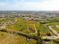

 REF AV-PBI-131231.120m²
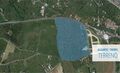 0
0
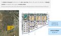
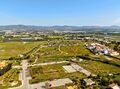
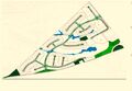
 REF AV-PBI-CG1264218.000m²Land in Tavira with 21.8 hectares, in the connection between the A22 and the city center of Tavira, in a place with excellent development potential. The land is located in the vicinity of the city of Tavira, in the Western Algarve, 37 km from Faro (39 km from the airport), 300 km from Lisbon and 172 km from Seville. The Pêro Gil Detail Plan, where the land is integrated, allows to develop a project with a total construction potential of 76,021sqm for residential space, a hotel, commercial space. The area is divided into three execution units and a rustic area, facilitating the proper phase of the project: Execution Unit 1 divides the space into nine lots, with one for hotel unit, five for collective housing (two of them with trade) and three lots for equipment (one of them, for private clinic). Part of the adjacent land will be kept rustic (79,885sqm), with agricultural potential. Execution Unit 2 divides the urban space into eight distinct lots for collective housing (where, in three of these, trade areas are expected to exist on the ground floor). This unit has a Nascent - West orientation. Execution Unit 3 is structured in twenty-seven separate lots, of which three are intended for collective housing and the remaining twenty-four for detached dwellings. In the northern part of the EU3, next to the EU2, the retention basin provided for in the Pêro Gil Detail Plan is inserted. In addition to the three Execution Units, which make up the Urban Area, there is a Rustic Area that will be maintained, conducive to agricultural culture, a total of 79,885sqm. The predominant crops in this region are of a wine and fruit nature. The Total Land Area amounts to 218,837sqm, corresponding to an Urban Area of 138,952sqm and a Rustic Area of 79,885sqm. The surroundings are characterized by the existence of land, mixed buildings and scattered villas.
 0
0

 REF AV-PBI-1280803.240m²
 0
0


 REF AV-PBI-BC9921210.414m² 313.386m²
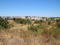 0
0

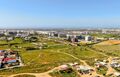
 REF AV-PBI-BC12511.056.878m²Joint sale of 84 properties (plots of land) distributed by 3 urban operations (PIP) approved for the amount of 28,900,000€, with Gross Construction Area of 239,840sqm, of which 189,489sqm for housing. Energy Class: Exempt Setúbal was born from the river and the sea. The records of human occupation in the territory of the municipality date back to prehistory, having been collected, in several places, numerous traces since the Neolithic. It was visited by Phoenicians, Greeks and Carthaginians, who came to Iberia in search of salt and tin, namely the Alcácer do Sal, a village until which the river was then navigable. During the Roman occupation, Setúbal experienced a huge development. The Romans installed in the village fish salting factories and ceramic ovens, which they also developed. The fall of the Roman Empire, the barbarian invasions and the constant piracy of cabotage caused the stagnation, if not even the disappearance, of the settlement between the 6th and 12th centuries. In particular in the last century, there are no records of the village, 'wedged' between the Christian Palmela and the Arab Salt Alcácer. In the century that followed, the royalty and nobility of that then settled seasonal residence in Setúbal. The time of discoveries and conquests in Africa brought to Setúbal a great development, with D. Afonso V and his army, in 1458, party ing from the port of Setúbal to the conquest of Alcácer Ceguer. Throughout the 15th century, the village developed various economic activities, mainly linked to the shipbuilding industry and maritime trade, taking high incomes from the duties charged for entry into the port. It is from the end of the 15th century, beginning of the 16th century, a period of frank national development, dating to the construction of the Convent of Jesus and its church, founded by Justa Rodrigues Pereira to house the franciscan female order of Santa Clara, and is most likely the architectural work of Master Diogo Baitaca, the same one who took care of the Jerónimos Monastery.
 0
0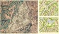

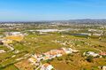
 REF AV-PBI-1228371.435m²Land with investment project in one of the noblest areas of the Algarve. This tourism investment project includes the construction of: - 182 residential apartments (condominium) - 21 and 27 detached houses - 24 semi-detached houses - 30 villas - 116 townhouses - 210 apartments All equipment and facilities as well as garden, club and services. Great location: 20 km from Faro airport, 1km from vilamoura marina and casino, 12 km from Quinta do Lago and 11 km from Vale do Lobo, 1 km from the beach, 65 km from Spain and with the nearby motorway 265 km from Capital Lisbon as well as Lisbon airport. Vilamoura was created in the former Quinta do Morgado de Quarteira, a farm with 1600 HA acquired by the founder, Mr. Arthur Cupertino de Miranda. The vilamoura resort project that we know today was created around vilamoura marina. It all started in the late '60s and early '70s. The first excavations began in 1971, and in 1974 the first sailboat entered the Vilamoura Marina. Vilamoura Marina has since grown and the resort of Vilamoura has grown around as well. Currently Vilamoura is already more than a marina. Due to the great positive acceptance that Vilamoura received from visitors and residents, Vilamoura has become over the years an important center of tourism and private residential accommodation. Vilamoura currently has recreational infrastructures that receive international recognition, namely: vilamoura marina, 5 golf courses, international college, tennis courts, running and fitness areas, sailing club, conference rooms with capacity for thousands of people. To increase the quality of time in Vilamoura, there are renowned hotels, restaurants, bars. The inhabitants and visitors of Vilamoura recognize that it is a place to live that offers the possibility to enjoy high quality of life
 3 bedroom Apartment